Provinces of Laos
From Wikipedia, the free encyclopedia
Laos is divided into provinces (
Lao ແຂວງ,
pronounced [kʰwɛ̌ːŋ],
khoeng,
qwang or
khoueng) and 1 prefecture (kampheng nakhon) plus the Vientiane Capital city municipality (ນະຄອນຫຼວງ, nakhon louang, or
Na Kone Luang Vientiane). The special administrative zone (ເຂດພິເສດ,
khet phiset)
Xaisomboun created in 1994 was dissolved on January 13 2006.
[1]
Distribution of provinces (updated after late 2013)

 |
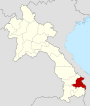
Attapu Province |
Samakkhixay District
(Attapeu) |
112,097 |
10,320 |
11 |
LA-AT |
 |
Bokèo Province |
Houayxay District
(Ban Houayxay) |
145,216 |
6,196 |
24 |
LA-BK |
 |
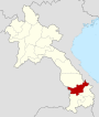
Bolikhamxai Province |
Paksane District
(Pakxan) |
225,272 |
14,863 |
14 |
LA-BL |
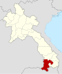 |
Champasak Province |
Pakse District
(Pakse) |
607,333 |
15,415 |
37 |
LA-CH |
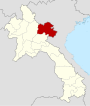 |
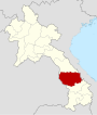
Houaphan Province |
Xamneua District
(Xam Neua) |
280,898 |
16,500 |
20 |
LA-HO |
 |
Khammouan Province |
Thakhek District
(Thakhek) |
337,314 |
16,315 |
22 |
LA-KH |
 |
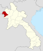
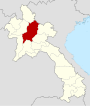
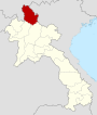
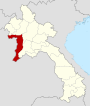
Luang Namtha Province |
Namtha District
(Luang Namtha) |
145,289 |
9,325 |
16 |
LA-LM |
 |
Louangphabang Province |
Louangphrabang District
(Luang Prabang) |
407,012 |
16,875 |
24 |
LA-LP |
 |
Oudômxai Province |
Xay District
(Muang Xay) |
265,128 |
15,370 |
18 |
LA-OU |
 |
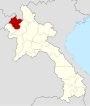
Phôngsali Province |
Phongsaly District
(Phongsali) |
165,926 |
16,270 |
12 |
LA-PH |
 |
Salavan Province |
Salavan District
(Salavan) |
324,303 |
10,691 |
31 |
LA-SL |
 |
Savannakhét Province |
Khanthabouly District
(Savannakhet) |
825,879 |
21,774 |
33 |
LA-SV |
| #Update map (politicaly changed since 2014) |
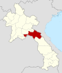
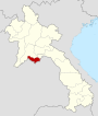
Vientiane Province |
Phonhong District
(Phonhong) |
388,833 |
15,927 |
23 |
LA-VI |
 |
Vientiane (Viengchan) Capital |
Vientiane |
698,254 |
3,920 |
180 |
LA-VT |
 |
Xaignabouli Province |
Xayabury District
(Sainyabuli) |
338,646 |
16,389 |
23 |
LA-XA |
 |
Xékong Province |
Lamarm District
(Sekong) |
84,985 |
7,665 |
11 |
LA-XE |
| #Update map (politicaly changed since 2014) |
Xaisomboun Province |
Anouvong District
(Anouvong) |
82,000 |
8,300 |
10 |
LA-XS |
| #Update map (politicaly changed since 2014) |
Xiangkhouang Province |
Pek District
(Phonsavan) |
229,521 |
15,880 |
18 |
LA-XI |
Prior to 2006 dissolution of Xaisomboun in 2006
While transliterates spelling may differ, the nomenclature used in
the 2005 census is as follows: Phongsaly, Luangnamtha, Oudomxay, Bokeo,
Luangprabang, Huaphanh, Xayaboury, Xiengkhuang, Vientiane Province,
Borikhamxay, Khammuane, Savannakhet, Saravane, Sekong, Champasack,
Attapeu, Xaysomboon.
[2]
Population
The population of each province in 2005 is given in the census data,
[3] ranging from the largest (Savannakhet) to smallest (Sekong).
History
In 1989 Vientiane prefecture was split from Vientiane province and
the capital of Vientiane province moved from Vientiane to Muang
Phôn-Hông. In 1994 Xaisômboun khetphiset (special region) was formed
from parts of Bolikhamxai, Vientiane, and Xiangkhoang provinces. In 2006
Xaisomboun special region was dissolved and the Longsan, Xaysomboun,
Phun, and Hom districts added to Vientiane province, while Thathon
district was transferred to Xiengkhuang province.
Further divisions
The provinces are then subdivided into
districts (
muang) and villages (
baan).
Geography
The provinces are grouped geographically into 3 strata, North (from
Phongsaly to Saiyabouly, Luang Prabang and Xiengkhuang), Central
(Vientiane and Bolikhamxay) South (from Khammuane to Champasack).
References


Tidak ada komentar:
Posting Komentar